The Grand
Canyon
Yellowstone's
Grand Canyon is one of the most iconic sites in the region, providing several
stunning vistas as you go along. This almost 40 km long canyon is a large and
the most famous canyon in Yellowstone. It is hugely popular among visitors due
to its scenic views of the Lower and Upper falls, as well as the fascinating
pink and yellow coloured rocks. There are several viewpoints and points of
interest along the length of the canyon. The canyon's beautiful shades of
colours are an iconic part of Yellowstone. The mineral stains due to the
activities of water have given the rocks of the canyon such a pleasant tint of
colours, it is truly a sight to behold. The geology of the canyon is not
completely clear. It was created due to erosion over hundreds of thousands of
years, and the geothermal nature of the area is still prevalent, which can be
seen by the hot springs throughout the canyon.

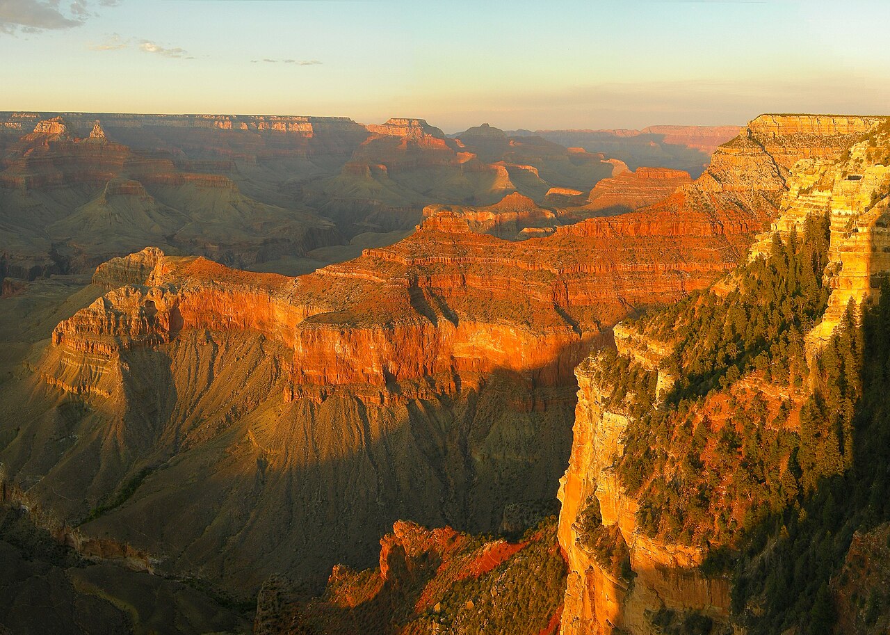
The Grand
Canyon is a river valley in the Colorado
Plateau that exposes uplifted Proterozoic and Paleozoic strata,
and is also one of the six distinct physiographic sections of the Colorado
Plateau province. Even though It is not the deepest canyon in the world (Kali Gandaki
Gorge in Nepal is much
deeper), the Grand Canyon is known for its visually overwhelming size and its
intricate and colorful landscape. Geologically, it is significant because of
the thick sequence of ancient rocks that are well preserved and exposed in the
walls of the canyon. These rock layers record much of the early geologic
history of the North American continent.
Uplift
associated with mountain formation later moved these sediments thousands of
feet upward and created the Colorado Plateau. The higher elevation has also
resulted in greater precipitation in the Colorado River drainage area, but not
enough to change the Grand Canyon area from being semi-arid. The uplift of
the Colorado Plateau is uneven, and the Kaibab
Plateau that the Grand Canyon bisects is over one thousand feet
(300 m) higher at the North Rim than at the South Rim. Almost all runoff
from the North Rim (which also gets more rain and snow) flows toward the Grand
Canyon, while much of the runoff on the plateau behind the South Rim flows away
from the canyon (following the general tilt). The result is deeper and longer
tributary washes and canyons on the north side and shorter and steeper side
canyons on the south side.
Temperatures
on the North Rim are generally lower than those on the South Rim because of the
greater elevation (averaging 8,000 feet or 2,400 metres above sea level). Heavy
rains are common on both rims during the summer months. Access to the North Rim
via the primary route leading to the canyon is limited during the winter season
due to road closures.

The Grand
Canyon area has some of the cleanest air in the United States. However,
at times the air quality can be considerably affected by events such as forest
fires Dust storms and in the Southwest.
What effect
there is on air quality and visibility in the canyon has been mainly from
sulfates, soils, and organics. The sulfates largely result from urban emissions
in southern California, borne on the prevailing westerly winds throughout
much of the year, and emissions from Arizona's copper smelter region, borne on
southerly or southeasterly winds during the monsoon. Airborne soils originate with windy
conditions and road dust. Organic particles result from vehicle emissions,
long-range transport from urban areas, and forest fires, as well as from VOCs emitted by vegetation in
A number of
actions have been taken to preserve and further improve air quality and
visibility at the canyon. In 1990, amendments to the Clean Air Act established the
Grand Canyon Visibility Transport Commission (GCVTC) to advise the US EPA on
strategies for protecting visual air quality on the Colorado
Plateau. The GCVTC released its final report in 1996 and initiated the
Western Regional Air Partnership (WRAP), a partnership of state, tribal and
federal agencies to help coordinate implementation of the Commission's
recommendations.
In 1999,
the Regional
Haze Rule established
a goal of restoring visibility in national parks and wilderness areas (Class 1
areas), such as the Grand Canyon, to natural background levels by 2064.
Subsequent revisions to the rule provide specific requirements for making
reasonable progress toward that goal.

Weather in
the Grand Canyon varies according to elevation. The forested rims are high
enough to receive winter snowfall, but along the Colorado River in the Inner
Gorge, temperatures are similar to those found in Tucson and other low
elevation desert locations in Arizona. Conditions in the Grand Canyon region
are generally dry, but substantial precipitation occurs twice
annually, during seasonal pattern shifts in winter (when Pacific storms usually
deliver widespread, moderate rain and high-elevation snow to the region from
the west) and in late summer (due to the North American Monsoon, which delivers waves
of moisture from the southeast, causing dramatic, localized thunderstorms
fueled by the heat of the day). Average annual precipitation on the South
Rim is less than 16 inches (41 cm), with 60 inches (150 cm) of snow;
the higher North Rim usually receives 27 inches (69 cm) of moisture, with
a typical snowfall of 144 inches (370 cm); and Phantom Ranch, far below
the canyon's rims along the Colorado River at 2,500 feet (762 m) gets just
8 inches (20 cm) of rain, and snow is a rarity.
Temperatures
vary wildly throughout the year, with summer highs within the Inner Gorge
commonly exceeding 100 °F (37.8 °C) and winter minimum temperatures
sometimes falling below zero degrees Fahrenheit (−17.8 °C)
along the canyon's rims. Visitors are often surprised by these
potentially extreme conditions, and this, along with the high altitude of the
canyon's rims, can lead to unpleasant side effects such as dehydration, sunburn,
and hypothermia.
Weather
conditions can greatly affect hiking and canyon exploration, and visitors
should obtain accurate forecasts because of hazards posed by exposure to
extreme temperatures, winter storms and late summer monsoons. While the park
service posts weather information at gates and visitor centers, this is a rough
approximation only, and should not be relied upon for trip planning. For
accurate weather in the canyon, hikers should consult the National Weather Service's NOAA weather
radio or the official National Weather Service website.
The National
Weather Service has had a cooperative station on the South Rim since 1903. The
record high temperature on the South Rim was 105 °F (41 °C) on June
26, 1974, and the record low temperature was −20 °F (−29 °C) on
January 1, 1919, February 1, 1985, and December 23, 1990.
I HOPE THAT YOU LIKE MY BLOG


Comments
Post a Comment